AI-Powered Exploration Intelligence
Guided by Mineral Systems Thinking
What is Xplore? Xplore™ is an advanced mineral exploration platform that combines knowledge-based geological models with cutting-edge machine learning. It incorporates 57 resource deposit models to interrogate all available geological data and interpret the geology.
The “Glass Box” Difference: Unlike traditional “black box” AI, Xplore creates a transparent ‘glass box’ of interpretation.
SEMANTIC REASONING
- Understands relationships & context between geological data
- Interprets, analyses, and infers new meaning
- Enables machines to understand and interact with geological language
- Produces defensible, explainable insights and not opaque predictions
WE TEACH MACHINES TO THINK LIKE GEOLOGISTS
- Built around fundamental mineral-system concepts
- Core technologies applied across projects
- Continuous innovation to solve exploration-specific challenges
WHY IS THIS IMPORTANT?
- Faster time-to-insight compared to traditional consulting or manual analysis
- Transparent, scientifically robust models built for scrutiny
- Outputs you can justify to boards, investors, and technical teams
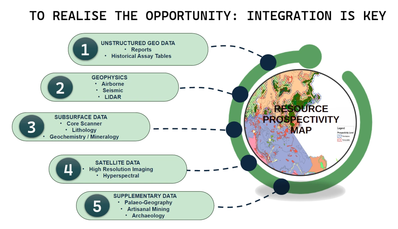
How It Works
1
Input
We ingest unstructured data (reports, logs), geophysics, subsurface data, and satellite imagery
2
Process
The Xplore engine creates a web of information and identifies geological connections and anomalies using proven geological principles
3
Deliver
You receive area, region, or country-scale mineral prospectivity maps for your chosen resource target
Our Packages

Ideal for
Early-stage
- Organization and cleaning of exploration data.
- Assessment of data quality and gaps.
- First-pass identification of permissive geological domains.

Ideal for
Target Generation
- AI-generated prospectivity maps for selected commodities.
- Recommendations on targeting and open ground opportunities.
- Clear explanation of why the model targeted specific areas.

Ideal for
Governments & Major Companies
- Bespoke country or regional-scale prospectivity analysis.
- Multi-commodity modelling.
- A turnkey solution for national-scale exploration planning.
Recent Success
Botswana Diamonds:
First AI pass generated 11 polymetallic and 3 kimberlite targets in just 8 weeks (compared to a typical 6–9 months).
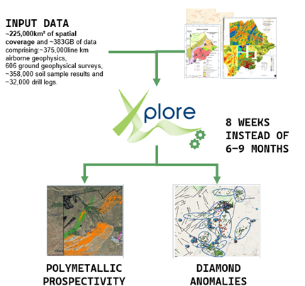
Listen to James Campbell talk about how using AI has change how they explore at Botswana Diamonds:
Case Histories
Case History: Accelerating Discovery of a New Resource Type in the United Kingdom Using Xplore
Overview
A major client approached us with a bold challenge: evaluate the potential for a completely new resource type in the UK — a region where this deposit style had never been explored. The area was large, the data landscape was chaotic, and no previous geological work existed to guide the search. Traditional exploration methods would have required more than 15 months just to complete the initial scoping.
Using our AI‑driven mineral exploration platform, Xplore, we delivered a full two‑phase exploration campaign in just three months, providing the client with the clarity and confidence to advance to the next stage of investment.
The Challenge
- Frontier-style exploration in a region with no prior work for this deposit type
- Extremely large search area with complex, multi‑source datasets
- Highly varied data types, including unstructured historical records spanning over 100 years
- A client requirement for a cost‑effective, staged approach that would:
- Phase 1: Determine whether the resource type was even plausible
- Phase 2: Narrow broad targets into high‑grade, ranked prospects
- Ensure each step justified further spend
This was a classic greenfield challenge — at regional scale and with no existing exploration framework.
Our Approach
1. Building New Geological Intelligence
We began by developing five novel deposit models, each representing a different geological scenario for how this new resource type could be deposited. These models became the backbone of the entire exploration workflow.
2. Data Discovery, Ingestion & Transformation
Using Xplore, we:
- Located and reviewed all available datasets
- Ingested and transformed diverse data types (structured, unstructured, geospatial, historical)
- Normalised and integrated them into a unified exploration-ready environment
Xplore’s ability to extract meaning from unstructured historical documents — some written over a century ago — proved critical. It identified pathfinder indicators that would have been nearly impossible to detect manually.
3. AI‑Driven Target Generation
Xplore interrogated the full dataset against the five deposit models, identifying areas that met the geological criteria for the resource type. This produced a set of broad, model‑driven target zones for Phase 1 and demonstrated the potential.
4. High‑Resolution Target Refinement
In Phase 2, we applied deeper analysis to:
- Rank targets by geological potential
- Reduce the size of each target area
- Highlight the highest‑grade prospects
- Converge on a single prime target zone for future work
Each step delivered clear, defensible outputs that allowed the client to confidently progress to the next stage.
Results
- Exploration timeline reduced from >15 months to 3 months
- Five new deposit models created for a previously unexplored resource type
- High‑confidence target areas identified across a vast region
- Unstructured historical data successfully mined for pathfinder indicators
- A single prime target zone defined for Phase 3
- The strength of the Phase 1 and 2 outcomes have prompted the client to evaluate Phase 3, with next‑stage planning already in motion.
This project demonstrated how Xplore can transform early‑stage exploration — turning uncertainty into actionable geological intelligence at unprecedented speed.
What This Case Demonstrates
This work showcases our ability to:
- Rapidly execute full exploration campaigns using AI
- Build bespoke geological models for new or unconventional resource types
- Integrate and interpret massive, structured and unstructured datasets
- Deliver staged, cost‑effective exploration workflows that de‑risk client decisions
For clients facing large areas, limited data, or novel geological questions, Xplore provides a faster, smarter, and more confident path to discovery.

Case History: National‑Scale Discovery in Scandinavia Powered by Xplore
Overview
Following the success of our pioneering exploration campaign in the UK, the same client commissioned a second and significantly larger project: a full‑country assessment of a Scandinavian country for the same resource type. This new mandate expanded the scope in terms of size of area assessed from a regional challenge to a national‑scale exploration programme, testing the scalability, adaptability, and multilingual capabilities of our AI‑driven platform, Xplore.
Despite the dramatic increase in area, data complexity, and linguistic diversity, Xplore delivered rapid, high‑resolution geological intelligence and identified multiple new prospective zones across the country.
The Challenge
The Scandinavia project introduced a new set of complexities:
- A vastly larger geographic footprint, covering the entire nation
- Foreign‑language datasets spanning Scandinavian dialects, and legacy terminology
- Highly variable data quality, from modern digital datasets to older records
- Multiple geological frameworks requiring integration and harmonisation
- A requirement to replicate and scale the successful UK
This was a true test of whether Xplore could operate effectively at national scale and across international data environments.
Our Approach
1. Scaling the UK Workflow
We deployed the same proven exploration architecture used in UK:
- Custom deposit models
- AI‑driven data ingestion and transformation
- Highly variable data quality, from modern digital datasets to older records
- Automated geological interrogation
- Target generation and ranking
But this time, we adapted it for a country‑wide dataset with far greater complexity.
2. Multilingual Data Integration
Xplore’s processing capabilities enabled us to:
- Translate and interpret foreign‑language geological reports
- Extract pathfinder indicators from historical Scandinavian documents
- Normalise terminology across multiple data sources
This ensured that no valuable information was lost due to language barriers.
3. National‑Scale Targeting
Once the data was harmonised, Xplore:
- Interrogated the entire country dataset against the deposit models
- Identified broad prospective zones
- Ranked and refined these areas based on geological potential
- Delivered a suite of targets across the country
Results
- Successful deployment of Xplore at national scale
- Foreign‑language and legacy datasets fully integrated and interpreted
- Multiple new prospective areas identified for the resource type
- Workflow replicated and scaled from regional to country‑wide with no loss of speed or accuracy
- Client confidence strengthened, demonstrating trust in both the technology and the team
This project proved that Xplore is not only innovative, but also robust, scalable, and internationally deployable, capable of delivering high‑quality exploration intelligence across borders, languages, and geological frameworks.
What This Case Demonstrates
The new campaign highlights our ability to:
- Scale AI‑driven exploration from regional to national level
- Overcome multilingual and heterogeneous data challenges
- Deliver rapid, defensible geological insights across international jurisdictions
- Provide clients with a repeatable, high‑value workflow they can trust
Focus Xplore
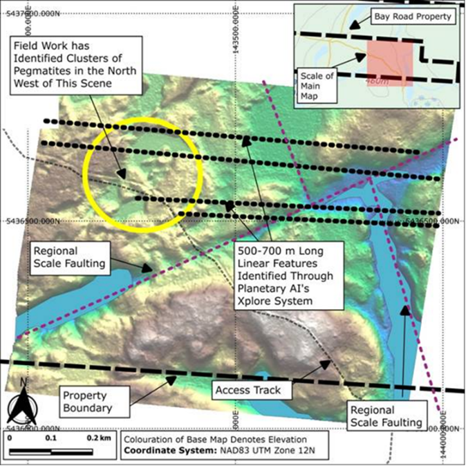
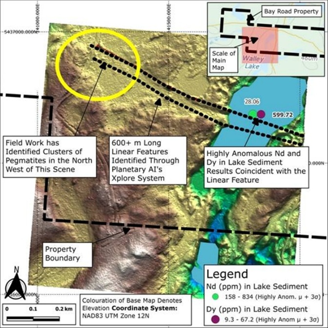
Case History: Rapid Multi‑Commodity Target Discovery in Ontario Using Xplore
Overview
Planetary AI was commissioned to identify new exploration targets across the Wabigoon Terrane in Ontario, with a focus on lithium, uranium, rare earth elements (REE), and other critical metals. The project was designed as a four‑month programme, with the first three months dedicated to rapid data integration, terrane appraisal, and early‑stage target generation.
Using our AI‑driven mineral prospectivity platform, Xplore, the project has already delivered results that significantly advance the client’s understanding of Ontario’s critical mineral potential and in several areas, has surpassed the maturity of their existing assets.
The Challenge
The Ontario project presented a complex, multi‑layered exploration challenge:
- A large and geologically diverse terrane requiring rapid appraisal
- A focus on multiple deposit types across critical minerals
- Huge volume of structured and unstructured geodata
- Legacy datasets of varying quality
- A requirement to deliver fast, defensible results to guide investment decisions
The client needed a system capable of integrating vast datasets, testing multiple geological models, and producing actionable targets within a tight timeframe.
Our Approach
1. Terrane‑Scale Geological Appraisal
We began by assessing all major terranes across Ontario, selecting the Wabigoon Terrane as the principal focus based on its geological potential for the targeted commodities.
2. Large‑Scale Data Integration
Planetary AI identified, reviewed, ingested, and transformed huge volume of structured and unstructured geodata.
Xplore’s automated ingestion pipeline enabled us to:
- Harmonise diverse datasets
- Extract meaning from legacy and unstructured sources
- Build a unified, exploration‑ready data environment
3. First‑Pass Prospectivity Analysis
A first‑pass analysis across 116,000 km² of the Wabigoon Terrane tested the integrated dataset against multiple deposit models.
This stage identified:
- More than 70 areas of interest in open ground
- A range of potential critical mineral deposit types
- Several zones with strong alignment to known mineralisation patterns
4. Target High‑Grading and Prioritisation
Using geological criteria, logistical considerations, and potential resource types, we:
- High‑graded the initial 70+ areas
- Selected 7 principal targets for detailed assessment
- Classified and archived the remaining targets for future work programmes
5. Advanced Analysis of Priority Targets
Two of the seven principal targets were taken to a highly detailed analysis stage.
Within these areas, Xplore identified zones suitable for staking that are more advanced than any of the client’s existing assets in the region.
Results
- Vast array of geodata integrated and transformed
- 116,000 km² analysed against multiple deposit models
- 70+ areas of interest identified across open ground
- 7 principal targets selected and high‑graded
- 2 targets advanced to detailed analysis
- New staking areas identified with maturity exceeding the client’s current portfolio
- AI‑driven results validated by alignment with known deposits and discovery of new high‑potential zones/li>
This project demonstrates that AI‑assisted mineral prospectivity can lower technical risk, significantly reduce costs, and deliver results far faster than traditional exploration workflows.
What This Case Demonstrates
The Ontario campaign highlights Planetary AI’s ability to:
- Execute rapid, multi‑commodity exploration at terrane scale
- Integrate and interpret massive, heterogeneous datasets
- Deliver high‑quality targets that materially advance a client’s asset base
- Apply Xplore effectively across new jurisdictions and geological settings
- Provide early‑stage insights that exceed the maturity of existing exploration portfolios
This project reinforces the value of AI‑driven prospectivity analysis as a transformative tool for modern mineral exploration.
Focus Explore CEO “The outputs generated by Planetary AI using their Xplore system have played a key role in shaping our early exploration decisions and have greatly improved our understanding of Ontario’s critical mineral potential. The team quickly integrated and interpreted a very large and complex dataset, producing clear, defensible targets that have materially advanced our exploration planning. Their ability to extract meaningful geological insight from such a complex dataset, while combining AI outputs with sound geological reasoning, gave us confidence throughout the process. The early results have already highlighted new areas with greater maturity than our existing assets, and have strengthened our belief in the potential of Ontario’s critical mineral systems.”
Focus Xplore: Integrated 20+ disparate datasets in 48 hours to reveal three previously overlooked target zones.